Via vehicle monitoring app, WEB-SAT provides professional solutions: Google Maps or, as a premium, additionally paid option, HERE Maps (new). You can use both maps or switch between them at any given time. Both solutions have their own strengths. Combining them gives you the best results and the ability to designate routes most efficiently.
Here Maps are perfectly suited for planning truck routes. With their use, the driver won’t be surprised by road obstructions or route restrictions. Available data include:
To best estimate the route, it is important to know the vehicle’s parameters. Thanks to this information, the HERE map will chart an optimal route suitable for the vehicle, depending on its height, type, and load. The following parameters can be assigned to a vehicle and taken into account when planning a route:
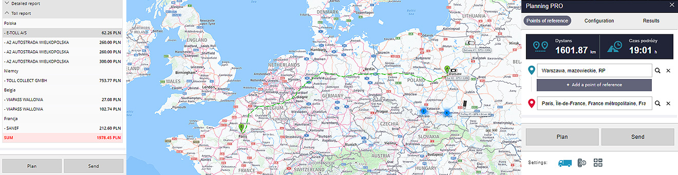
Tolls are an important element affecting the overall route cost. Long, international routes make it necessary for trucks to move via expressways and highways. The delivery deadlines require that the routes be planned with great accuracy. Obviously, time and money are the most important factors. HERE map meets its users' needs, as the cost of the set route is available in the toll report.
What does this report look like and what can you find there? Below is an example of a truck route from Warsaw to Paris. The report outlines the cost of tolls to be paid by the driver on designated roads and highways. There is also a division into domestic and foreign sections. Fees are assigned to specific routes and calculated in PLN. This is undoubtedly a convenient, helpful tool for planning routes and estimating costs.
If you are interested in the solution, we invite you to contact your WEB-SAT account manager, who will be happy to provide you with more details, access to the trial version, and a tailored quote for the implementation of the HERE Maps solution.